How does synthetic OLI compare with real Landsat?
Current empirical scope: one next-day acquisition pair
One R10C NEON flight from 15 September 2021 was independently compared with Landsat 8 on 16 September. This is not multisite real-sensor validation and is separate from the library polygon observations.
The reusable workflow
Corrected NEON → undarkened synthetic OLI → area-weighted aggregation to actual Landsat footprints → Collection 2 Level-2 surface reflectance → joint QA and coverage → agreement diagnostics. Brightness-adjusted synthetic OLI is evaluated as a paired secondary variant, not silently substituted for the primary result.
- Inspect all scene candidates and their temporal/footprint/QA suitability. Rank usable scenes using the recorded policy; retain rejected candidates. Same-day ETM+ is not automatically a compatible seven-band OLI reference.
- Decode QA_PIXEL fill, dilated cloud, cirrus, cloud, shadow and snow flags; reject relevant QA_RADSAT band saturation and terrain occlusion.
- Use official SR scaling: DN × 0.0000275 − 0.2 on valid stored values. Finite negative SR is not automatically clipped. NEON scaling must be independently declared or verified from source metadata, never guessed.
- Aggregate corrected/synthetic data to the actual north-up projected 30 m grid using source-cell area intersections. The primary valid-coverage threshold is 90% of the whole Landsat footprint, not only its overlap with available high-resolution pixels. Require joint support across variants and all seven bands. Cross-CRS calculations transform source cell geometry.
- Retain original registration and all accepted cells for primary metrics; inspect nine declared ±30 m offsets as sensitivity, not an optimized fit.
The module reference documents
FlightValidationInput, FlightValidationConfig and
compare_flight_to_real_landsat. The
example
accepts explicit source paths and times. STAC discovery needs the optional
landsat extra/network; normal numerical tests use offline fixtures/mocks.
What the pilot shows
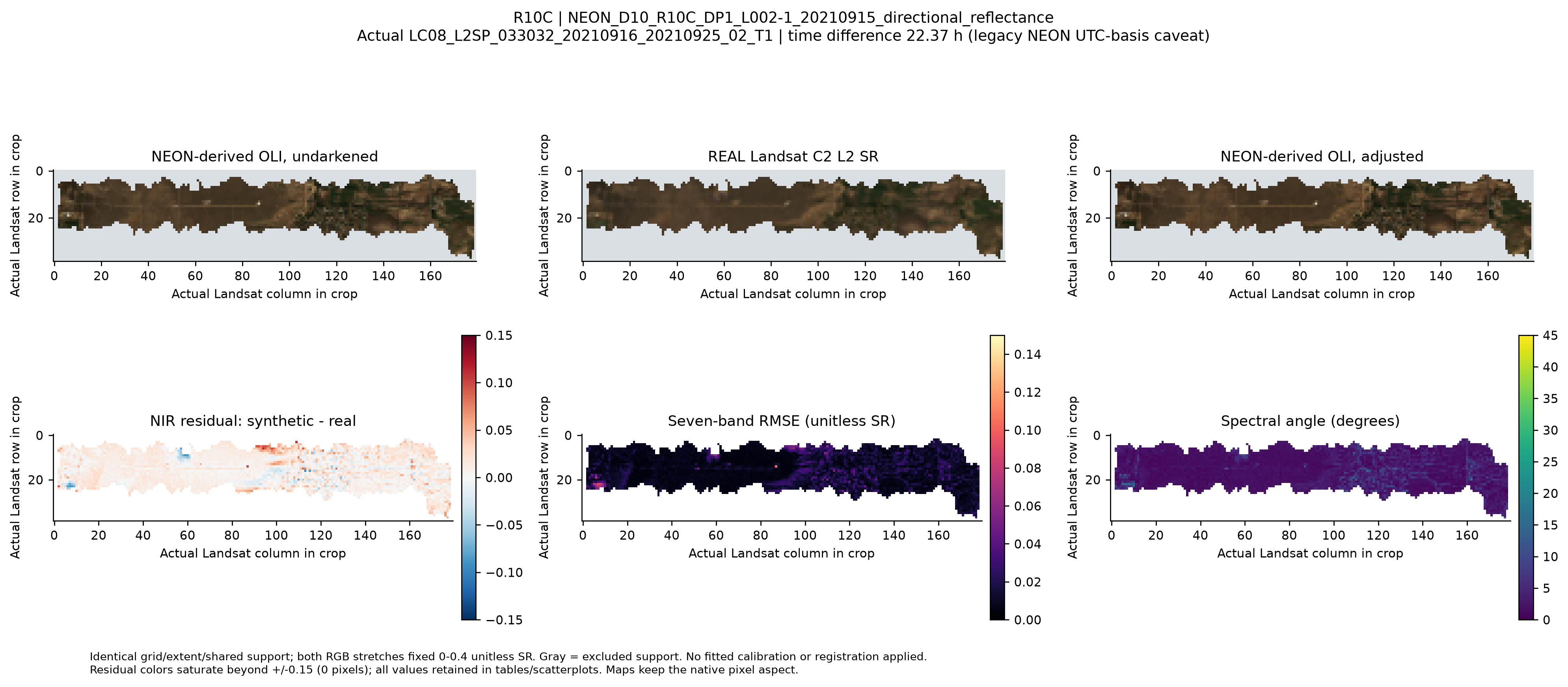
Open the pilot comparison at full resolution
The recorded comparison uses a common grid, spatial extent, valid mask and fixed 0–0.4 RGB stretch. Maps and residuals are empirical; no synthetic landscape is invented. Open the retained comparison and methods.
The primary undarkened comparison has 3,583 footprints in 56 spatial blocks: pooled seven-band RMSE 0.01477 reflectance, median spectral angle 2.089°, and bandwise Pearson r 0.810–0.945. Correlation measures association; it is not radiometric agreement. Bias, MAE/RMSE, identity/Deming fits, Bland–Altman residuals and spectral angle measure different aspects of agreement.
The nominal lag is +22.37 h, conditional on a legacy NEON timestamp interpreted as UTC; its suffix does not independently verify timezone. Original alignment is best among the nine offsets. Higher subpixel heterogeneity accompanies larger errors. Brightness adjustment gives mixed bandwise changes; the paired overall uncertainty interval spans zero. Spatial-block intervals preserve local clustering; individual cells are not independent field replicates.
Before broader claims: resolve time/coefficient-training provenance, add independent flights/sites, and assess PSF, subpixel alignment and block-size sensitivity. This pilot does not validate actual PFT abundance maps.