Validation: Topographic correction
Recorded evidence: 5 variations; 5 passed, 0 failed, and 0 skipped (100.0% pass rate over all recorded variations).
Evidence boundary
The current checked-in campaign uses small synthetic or already-present inputs and does not contact NEON. It validates software contracts and diagnostics, not real-flightline scientific accuracy.
What this module test exercises
Apply SCS+C to controlled synthetic terrain and confirm that correction reduces the injected reflectance relationship with illumination geometry.
Implementation exercised: calc_cosine_i and apply_topo_correct
Inputs varied
| Field | Why it is recorded |
|---|---|
slope_max_degrees |
Varies terrain from gentle to steeper slopes. |
scale_factor |
Alternates unit reflectance and 10,000-scaled storage. |
shape_y_x_b |
Varies spatial dimensions and band count. |
Checks and how to interpret them
| Check | Question | PASS means | If it does not pass |
|---|---|---|---|
shape_preserved |
Does correction retain the cube shape? | Corrected and input arrays have identical dimensions. | Inspect band/spatial axis handling and tile assembly. |
all_values_finite |
Did valid synthetic support remain numerically defined? | All corrected values are finite for this no-NoData fixture. | Inspect divisions, invalid geometry, and correction-factor bounds. |
terrain_correlation_reduced |
Did SCS+C reduce the deliberately injected illumination dependence? | Absolute correlation with cosine incidence is lower after correction. | Review coefficients and geometry; this check is directional, not an accuracy threshold. |
Diagnostics recorded for every variation
| Field | Why it is recorded |
|---|---|
incidence_correlation_before |
Absolute pre-correction geometry correlation. |
incidence_correlation_after |
Absolute post-correction geometry correlation. |
correlation_reduction |
Before minus after correlation. |
finite_percent |
Percent of corrected cells that are finite. |
mean_absolute_change |
Average correction magnitude in unit reflectance. |
Input variations and results
On narrow screens, scroll the table horizontally to see every diagnostic and check.
| Variation | Input variation | Result | Diagnostics | Explicit checks |
|---|---|---|---|---|
topographic_correction-001SCS+C correction over terrain slopes up to 5°. |
scale_factor=1; shape_y_x_b=[8,9,3]; slope_max_degrees=5 |
PASS | correlation_reduction=0.867244; finite_percent=100; incidence_correlation_after=0.132756; incidence_correlation_before=1; mean_absolute_change=0.0015484 |
all_values_finite=✓; shape_preserved=✓; terrain_correlation_reduced=✓ |
topographic_correction-002SCS+C correction over terrain slopes up to 10°. |
scale_factor=0.0001; shape_y_x_b=[9,10,4]; slope_max_degrees=10 |
PASS | correlation_reduction=0.909479; finite_percent=100; incidence_correlation_after=0.0905207; incidence_correlation_before=1; mean_absolute_change=0.00337437 |
all_values_finite=✓; shape_preserved=✓; terrain_correlation_reduced=✓ |
topographic_correction-003SCS+C correction over terrain slopes up to 15°. |
scale_factor=1; shape_y_x_b=[10,11,5]; slope_max_degrees=15 |
PASS | correlation_reduction=0.952548; finite_percent=100; incidence_correlation_after=0.0474518; incidence_correlation_before=1; mean_absolute_change=0.00545464 |
all_values_finite=✓; shape_preserved=✓; terrain_correlation_reduced=✓ |
topographic_correction-004SCS+C correction over terrain slopes up to 20°. |
scale_factor=0.0001; shape_y_x_b=[8,12,3]; slope_max_degrees=20 |
PASS | correlation_reduction=0.996449; finite_percent=100; incidence_correlation_after=0.00355099; incidence_correlation_before=1; mean_absolute_change=0.00606101 |
all_values_finite=✓; shape_preserved=✓; terrain_correlation_reduced=✓ |
topographic_correction-005SCS+C correction over terrain slopes up to 25°. |
scale_factor=1; shape_y_x_b=[9,9,4]; slope_max_degrees=25 |
PASS | correlation_reduction=0.950993; finite_percent=100; incidence_correlation_after=0.0490067; incidence_correlation_before=1; mean_absolute_change=0.00837028 |
all_values_finite=✓; shape_preserved=✓; terrain_correlation_reduced=✓ |
What a passing result establishes
Numerical shape, scaling, finite-value, and directional decorrelation behavior.
What it does not establish
Ecological signal preservation or optimal correction on real terrain.
The matching real stage checks are explained in the stage QA test guide.
Example from the real R10C test run
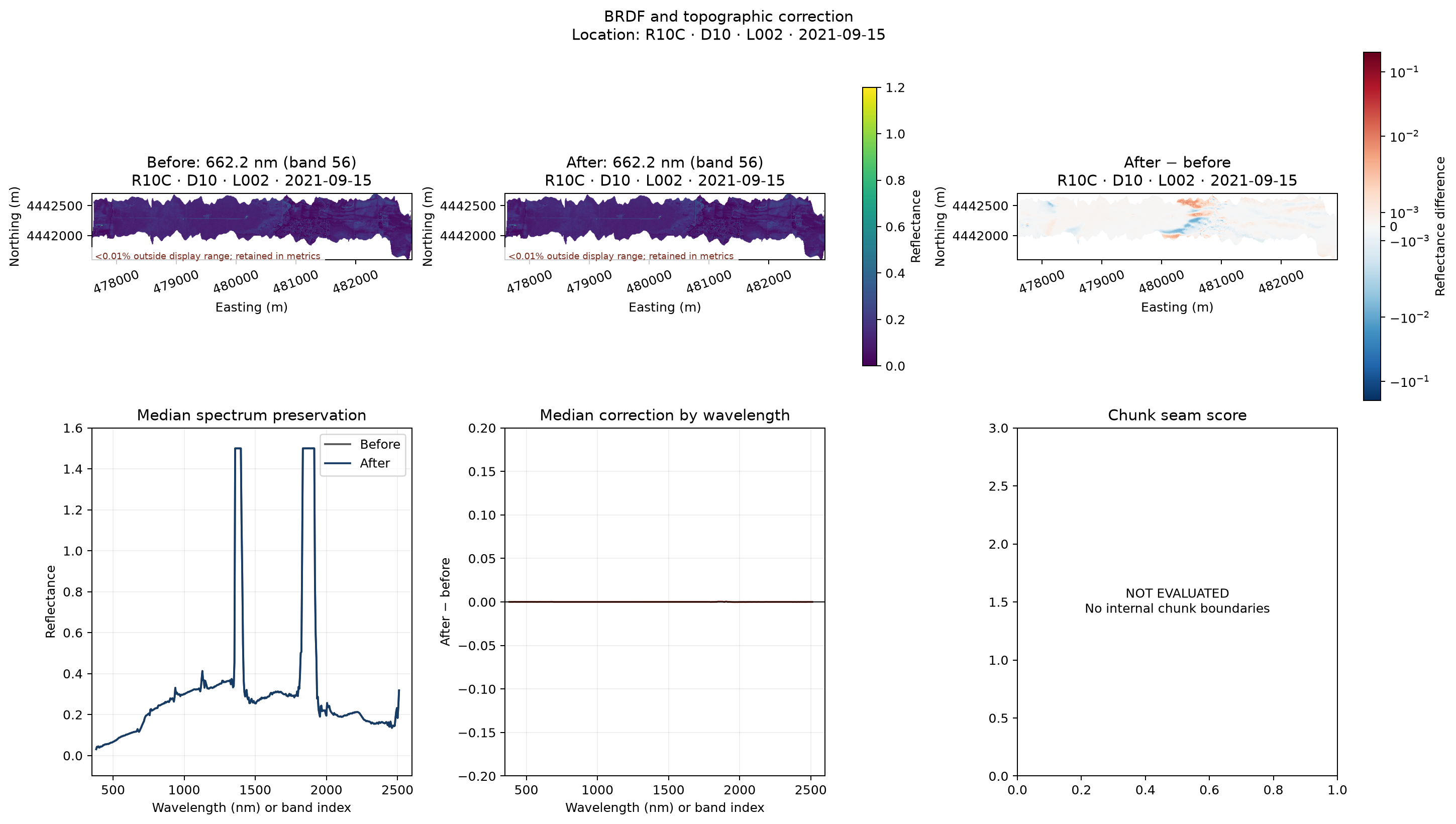
The figure is evidence from one completed flightline, not a replacement for the variation table above. Open the real flightline walkthrough for exact values and limitations.
Expansion to 100 real variations
The repository includes a live 100-flightline campaign specification. It requires a pinned inventory of real flightline IDs plus an explicit compute, storage, and network allocation. Live results must be stored as a new campaign record; they must not overwrite this offline baseline.
Reproduce or expand this module
# Fast local evidence matrix (five variations per module)
python scripts/run_validation_campaign.py --iterations-per-module 5

# Exercise 100 deterministic small-data variations per module
python scripts/run_validation_campaign.py --iterations-per-module 100 \
  --output validation/results/offline-contract-100.json

python scripts/generate_validation_docs.py
The 100-case offline command scales contract variation and randomized synthetic inputs. It does not substitute for 100 distinct NEON downloads.
Last updated: 2026-08-14